April 27, 2020 – Whether you’ve just purchased a new mobile mapping system or are considering adding mobile mapping technology to your toolbox, you want to see a return on your investment as fast as possible.
As with any technology or tool you add to your capabilities, the best way to hit the ground running is to learn from the experiences of others and try to avoid common mistakes so you don’t spend a lot of time getting up to speed.
In my role as a reality capture application engineer at Leica Geosystems, I’ve assisted dozens of companies in their transition to mobile mapping and have observed how some basic approaches to mobile can make a big difference. So I thought I’d offer a few tips for getting started and finding early success.
———————————————————-
NOTE: The new Leica Pegasus TRK, launched in May 2022, makes success with mobile mapping even easier through its autonomy, intelligence and simplicity. Learn more about the Pegasus TRK here >
———————————————————-
1. Create a mission plan
As with field work of any kind, it is important to think about the scope of work and what type of deliverables need to be produced before gathering any data. The field work should be collected in a manner that complements the project objectives and the production needs. A mission plan should consider:
- Project limits
- Site specific safety considerations
- Ground control placement for survey grade accuracy
- Data collection path routing and overlap
- Building types and tree canopies in the area that might obstruct GPS signals
- LiDAR resolution; does the project have points per square meter requirement?
- Image frequency; how often the cameras trigger
- Time of day for vehicle or pedestrian traffic density
- Time of day for optimal GPS satellite constellation geometry, which will influence trajectory calculations
- GPS base station placement, which will influence trajectory calculations
These are very important considerations for success on any mobile project. All this information should be detailed for the field crew to utilize to ensure safety and productivity during the collection.
 “Having properly calibrated and oriented data (LiDAR, images, etc.) allows data from various sensors to be spatially complementary to one another.”
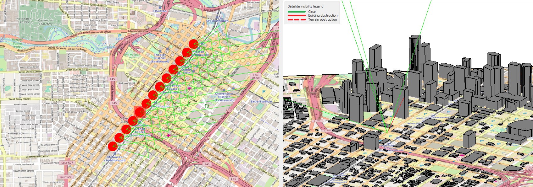
To make this easier, look for a mobile mapping system that allows you to make use of planning in a way that is part and parcel of the system. One great feature in the Pegasus Manager suite is the Mission Planning module, which integrates a streaming 3D building layer that will inform you when you’ll have the best satellite coverage for GPS and at what point in your route you will encounter satellite obstructions. This can be very useful determining ground control placement. It will also advise on best time of day to avoid any sun glare in images, if that is an important consideration. All this information, including any reference files you may have such as a background map or image, survey control, project limits, or collection path guidelines, can all be easily bundled up and exported directly to the Pegasus solutions for real-time field crew reference.
2. Field check the system before collection
- Before collecting data, power up the system and review the following:
- If the unit was shipped to your project site by a third party, check the system for any physical disruption that may have occurred during shipment; sometimes shipping companies push the limits on how they handle items!
- Check that everything is securely connected to the system and to the collection vehicle; this is an important safety consideration for field technicians and the general public
- Check storage capacity on the internal or external hard drive where you plan to store mission data
- Check the battery level of the system
- Make sure mission planning files (SHP, DXF, KML, TIFF, etc.) that will be used as a spatial reference during collection are loaded on the unit
- Check connectivity to any attached sensors such as a 2nd GNSS antenna, DMI wheel sensor, pavement cameras, thermal cameras, etc.
Routine checks like this will ensure a smooth collection and accurate results.
3. Be engaged and be safe
The practice of mobile mapping is exciting and liberating. It is common to be awed by the elegance and efficiency of mobile data collection. Even after countless missions, I still get a real charge out of easily collecting a site in 30 minutes that may have taken three weeks by other methods. It’s an incredible culmination of technology that is easy to employ in the field, once you’re properly trained.
That said, it’s important to stay focused and be mindful of your surroundings and your influence on the general public. For vehicle-based collections, I recommend two-person crews. One person should safely operate the vehicle and have their attention on nothing but that—checking mirrors, using turn signals, obeying speed laws; all the standard considerations. This person also needs to be aware of other vehicles that may be traveling behind the mobile mapping vehicle and obstructing images and LiDAR while making sure that pre-determined collection routes are being safely navigated. The often-inquisitive public can also be distracted by mobile systems, so it’s crucial to stay vigilant and safe.
The second person can be monitoring the mobile platform interface, making sure the system is functioning properly and camera trigger events are properly spaced, monitoring the health of the collection accuracy as site conditions change, advising the driver on project limits and any project specific considerations that are approaching, etc. These two individuals work together to maximize safety and efficiency.
“Results can be reviewed in the field to ensure adequate coverage or shared with a customer who has time-sensitive questions about their project.”
For wearable mobile mapping, like with the Pegasus Backpack, considerations for a building being documented or a site being collected need to be thought out. Can the operator maintain three points of contact on sites that require it? Will there be heavy earth moving equipment operating in the area? Will there be excessive pedestrian traffic? Is privacy a concern in the imagery, as may be the case in a hospital?
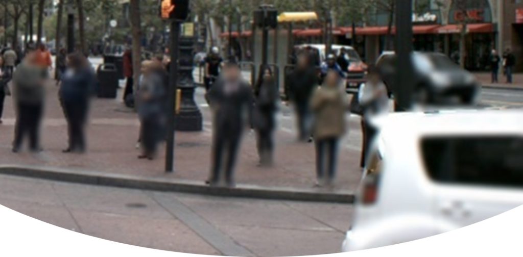
For privacy issues, processing suites like Pegasus Manager, which offers pedestrian and vehicle blurring in the images, can alleviate concerns from government or healthcare partners that want to employ mobile reality capture but do not want to compromise the privacy of the public. This feature in the Pegasus Manager uses artificial intelligence and machine learning to obscure people and vehicles directly in the RAW field data so that no future iterations of the data can be processed without blurring.
4. Start post-processing right away
Travel time can be processing time. Once the collection is finished, there is usually an opportunity to begin post-processing right away. Pegasus Manager, being a batch-operation driven solution, allows users to quickly configure the post-processing functions and begin crunching data in as little as five minutes. A standard mobile CAD workstation will have plenty of power for processing, and the Pegasus solution just requires a couple button clicks to get started. On most jobs, results can be reviewed in the field to ensure adequate coverage or shared with a customer who has time-sensitive questions about their project.
5. Get creative
Mobile mapping isn’t just for doing traditional jobs faster. It also presents possibilities for new markets entirely. For instance, if you’re a surveyor used to doing detailed plans for roadway or site design, your mobile mapping system will absolutely help you do that faster, by several orders of magnitude. But you may also consider jobs like sign inventory work on roadways or imagery-based work in buildings that just wasn’t possible or practical with other collection methods.
Even if you’ve always been design and engineering focused, mobile mapping opens a whole world of GIS jobs, building and construction documentation, rapid topo-mapping, railroad collections, simulations for public safety or autonomous vehicles, mapping for plant renovations, and even work for video games and virtual reality. With mobile mapping, you have an opportunity to expand your business to new frontiers.
Obviously, some of these new jobs won’t be in your traditional wheelhouse and might introduce some trepidation. How do you approach these projects? How are others doing this work? How do I collect and manage all the data? That’s why it’s vital you find a mobile mapping system provider willing to work with you on monetizing your system to create that return on investment.
To talk to me or one of our other experts and learn more about mobile mapping or other surveying solutions, please contact us.
About the Author:

For over 20 years Jason Ellis has been an agent of change by way of technology and a passionate advocate of all things geospatial. Every day he works to help organizations transform their potential by exploring and implementing mobile reality capture solutions. As the North American mobile mapping sales and technical consultant for Leica Geosystems, he works closely with collaborators who are driving reality capture and helping to shape the landscape of the industry. Follow Jason on LinkedIn.