‘Don’t wait for the right opportunity, create it.’
-George Bernard Shaw
 Feb. 27, 2021 – When I first became aware of LiDAR, it was a revelation. I had already been working in surveying and civil engineering for about a decade, in the field and in the office, and at the time was deeply entrenched in CAD management and IT operations for my company.
I was asked about storage capacity options for a new technology my company was pursuing. When they started throwing out numbers suggesting 10+ gigabytes of data per project, I was stunned. I was accustomed to working with point files averaging in the kilobyte to megabytes in size… but several gigabytes of point data? What exactly was going on with this technology?
I had heard a little about LiDAR and some of the applications it could enhance, but it wasn’t until I saw the scanner in action – and more impressively, saw the digital results of the point cloud – that I truly understood the potential this technology had to revolutionize the industry. Seeing a point cloud of our survey operations room being spun around in 3D space was mind-blowing. The ability to capture reality in digital form at such a rapid pace was staggering.
From that day forward, I was determined to work with LiDAR and do everything I could to help progress the industry to embrace this amazing technology. I spent the next several years helping my company provide scanning services and grow awareness of its value while creating opportunity on a regional and national scale.
“It wasn’t until I saw the scanner in action – and more impressively, saw the digital results of the point cloud – that I truly understood the potential this technology had to revolutionize the industry. The ability to capture reality in digital form at such a rapid pace was staggering.”
– EllisThe next sea-change moment for me was the realization of mobile mapping. Mobile mapping was something that I had read a little about in industry publications, but to me it was a somewhat obscure technology that seemed out of reach in both scope and price, and some of implementations I saw pictures of looked like complicated science experiments.
So while I was aware of mobile mapping, it wasn’t until I started pursuing a career with Leica Geosystems that I began to understand the massive opportunity potential mobile mapping platforms reveal to the surveying industry.
———————————————————-
NOTE: The new Leica Pegasus TRK, launched in May 2022, brings even more opportunities for mobile mapping through its autonomy, intelligence and simplicity. Learn more about the Pegasus TRK here >
———————————————————-
Three Clear Benefits of Mobile Mapping
One of my first collections with the Pegasus system was when it all came into clear focus for me.
It was a cold day in Atlanta with snow flurries, which is rare, indeed. We quickly installed the Pegasus on the vehicle, initialized it, then started driving around a large event venue site. As we drove, several immediate benefits became obvious to me (besides surveying from inside of a heated truck).
1. The speed of data collection is unmatched. We were collecting a full roadway dataset in a 150-meter wide corridor at posted driving speeds, and further, the post-processed LiDAR data would be automatically geo-referenced due to the onboard navigation system. No backsights to manage, no instrument height measurements, no long treks up and down the roadway; just fasten it to the vehicle, turn it on, and go. That morning we collected before lunch what would have easily taken a conventional field crew a week or more (140 acres, all parking lots\islands, buildings, walks, topology, paint striping, pole locations, above ground utilities, etc).
2. Data collection is much safer. How many safety meetings for considerations on worker protection, traffic control and signage had I participated in? How many extra workers deployed to execute and mange the plans on-site? How many permit processes for lane closures and access? How many inconsiderate or distracted drivers that ignored every conceivable safety sign, flashing light and warning installed on the job site? With mobile mapping, we were just another vehicle on the road, but we were collecting a dizzying amount of detail. No permits needed, no signage, no dodging vehicles – virtually no risk.
3. The imagery is invaluable. The Pegasus being outfitted with multiple high-resolution cameras meant we were also capturing a photographic record of every detail of the collection site that could be used for 360 degree reference imagery, sign location, utility location\paint markings, pavement conditions, true color point clouds, photogrammetry measurements to infill LiDAR occlusions, overlaying LiDAR and images for verification and validation. Every detail documented, while merely driving.
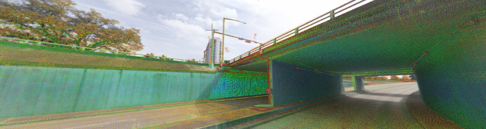
All this data is anchored by a robust navigation system that combines GNSS (Global Navigation Satellite System) and an IMU (Inertial Measurement Unit) which cooperate to situate the data in its true location on the Earth’s surface. The GNSS tracks all available satellite constellations and the IMU measures the movement of the vehicle (roll, pitch and yaw). The result is a pristine point cloud void of any vehicle motion error, along with a full complementary photographic dataset that overlays with the LiDAR, placed on the Earth’s surface to within a few centimeters of global accuracy. If the initial global accuracy of the data needs to be tighter, it can be constrained further to sub-centimeter accuracy using survey control targets.
Unmatched Safety, Efficiency and Agility
In short, mobile mapping creates an opportunity for field operations to be exponentially safer, more efficient and more agile. Being able to quickly deploy a system to collect miles\acres of highly detailed data in a single afternoon is a complete game changer. Be it by road, rail or water, there simply is no faster way to accurately capture existing conditions than by mobile mapping.
With the advent of mobile mapping, my passion for reality capture has only intensified and is regularly reinvigorated by the success stories from our customers and the advancements that Leica Geosystems continues to pursue. The Pegasus mobile mapping offerings, for both vehicles and pedestrians, are an amazing confluence of proven technologies crafted into elegant, efficient, and effective solutions. It is my pleasure to help organizations throughout the United States examine and implement these transformative mapping solutions.
To talk to me or one of our other experts and learn more about how to maximize opportunities in your surveying business, please contact us.
About the Author:

For over 20 years Jason Ellis has been an agent of change by way of technology and a passionate advocate of all things geospatial. Every day he works to help organizations transform their potential by exploring and implementing mobile reality capture solutions. As the North American mobile mapping sales and technical consultant for Leica Geosystems, he works closely with collaborators who are driving reality capture and helping to shape the landscape of the industry. Follow Jason on LinkedIn.