Feb. 20, 2020 – Mobile mapping systems (MMS) are rapidly gaining ground as a fast, accurate way to map large areas. If you’re thinking about investing in an MMS, which system you may want to use will depend on what you’re trying to accomplish. Or, in professional terms: “What’s the deliverable?”
Really, the primary determining factor for investing in any MMS that’s being advertised to you is whether the system will collect data accurate enough to achieve the requirements of your projects. But making sure you get the maximum return for your investment requires asking four key questions of any system.
1. Are the sensors calibrated to one another?
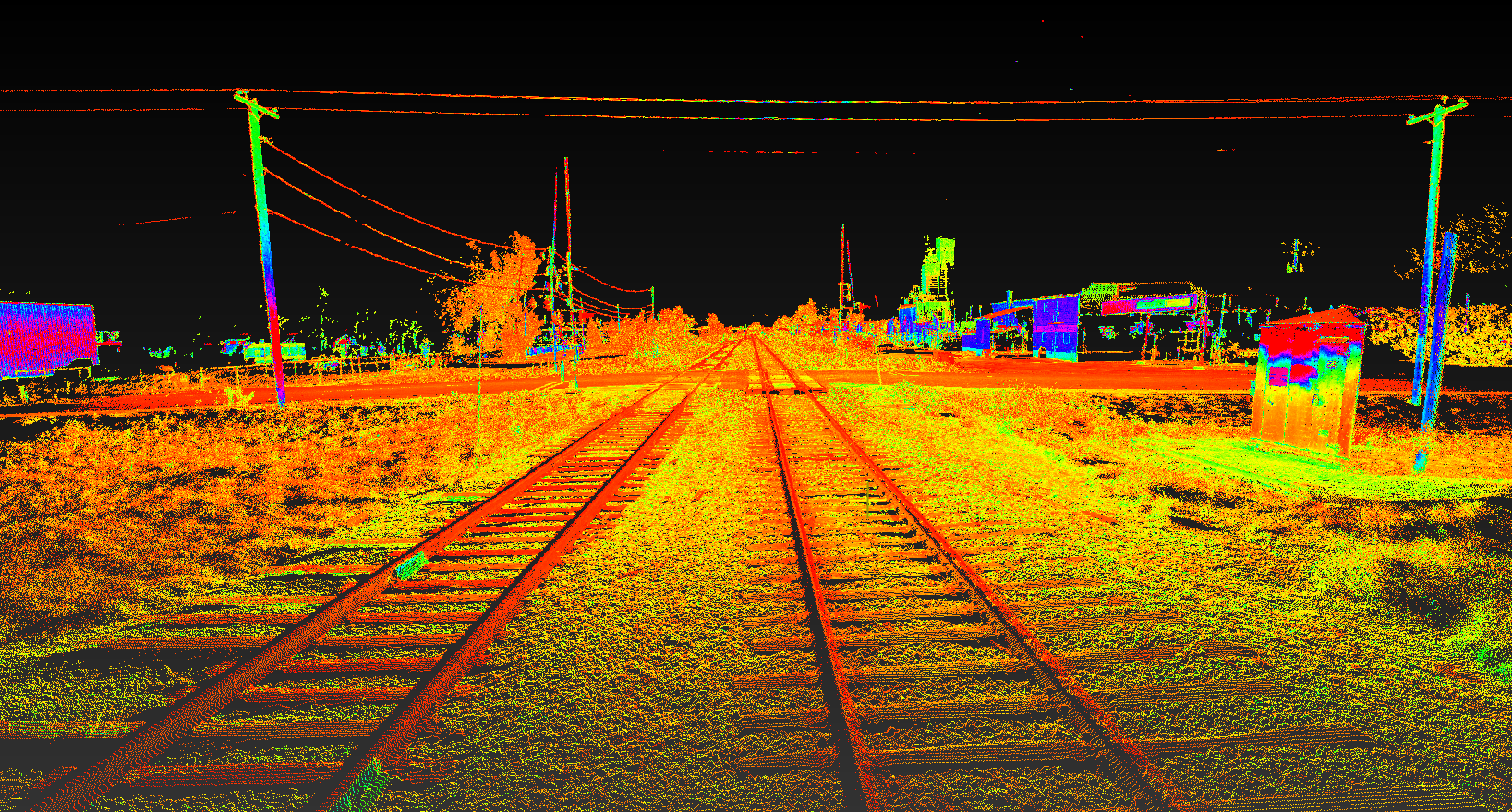
To be as effective as possible, once datasets from the sensors are placed along the trajectory (via time relationship), they can be oriented to the trajectory using calibration – or ‘lever arm’ – information. These calibrations are merely records of how each sensor is physically situated or connected to the MMS. Having properly calibrated and oriented data (LiDAR, images, etc.) allows data from various sensors to be spatially complementary to one another.
For example, in LiDAR data collection it is common to find areas of “shadowing,” or areas that were obscured from the line of sight of the scanner. However, if the LiDAR and cameras of a mobile mapping system are calibrated to one another and properly oriented to the trajectory, we can use the camera images to supplement our LiDAR dataset, enabling us to take point to point measurements, query coordinates, generate features, or infill our understanding of the space that was obscured from the LiDAR.
 “Having properly calibrated and oriented data (LiDAR, images, etc.) allows data from various sensors to be spatially complementary to one another.”
2. How flexible is the form factor?
Mobile mapping systems come in all shapes and sizes. Are you mapping an indoor space with an uneven floor and multiple sets of stairs? Maybe a handheld or backpack-based mobile mapping system makes sense. Are you mapping rail yards or crossings? A system on a high rail may be ideal. Are you mapping a roadway or riverbanks? Then you’ll most likely want something that can be mounted on a car or boat.
3. What is the system’s accuracy?
A wide variety of options can be used to capture a precise location. If the system utilizes mapping-grade GPS for establishing position, that might be fine if you were trying to create a map of air quality for a county GIS system. It’s unlikely the parts-per-million of a pollutant will vary significantly on a meter-per-meter basis. However, if you’re trying to map the beam configurations on highway overpasses for design purposes, that’s probably not going to be acceptable.
Check the system specifications for a trajectory accuracy that meets or exceeds typical project tolerances. Is sub-centimeter achievable with the system you are considering? How much time and effort does it take to achieve to that accuracy? Not all post-processing platforms are created the same, so reviewing the details of the workflow is important.
“In the expanding realm of mobile mapping, you should be looking to work with solutions that offer accuracy and flexibility.”
4. Will the system fit within your existing workflow?
An important question when considering any MMS is whether it will fit smoothly into how you already do things, or whether you’ll have to invest in new software, new training, or new servers and workstations to incorporate it into your business operations.
The MMS might have all the field functionality you’re looking for, but if it doesn’t export the data in a way that you can work with, it will surely be a frustrating experience. Our Pegasus MMS solution is designed to complement Leica products like Cyclone, Jet-Stream, and Cloudworx, but it is also very important to us that we support software like TopoDOT and industry standard formats like e57, LAS, Autodesk ReCap, and more.
In the expanding realm of mobile mapping, you should be looking to work with solutions that offer accuracy and flexibility. These characteristics will allow you to meet or exceed the project requirements and create the necessary deliverables for a variety of different contractors and downstream consumers of data.
To talk to me or one of our other experts and learn more about mobile mapping or other surveying solutions, please contact us.
———————————————————-
NOTE: The new Leica Pegasus TRK, launched in May 2022, brings advanced capabilities to mobile mapping through its autonomy, intelligence and simplicity. Learn more about the Pegasus TRK here >
———————————————————-
About the Author:

For over 20 years Jason Ellis has been an agent of change by way of technology and a passionate advocate of all things geospatial. Every day he works to help organizations transform their potential by exploring and implementing mobile reality capture solutions. As the North American mobile mapping sales and technical consultant for Leica Geosystems, he works closely with collaborators who are driving reality capture and helping to shape the landscape of the industry. Follow Jason on LinkedIn.