

Launching a new GIS department in an established engineering firm is challenging under the best of circumstances. Factor in the need to teach seasoned engineers and surveyors where and how it can add value and how to integrate GIS into their daily workflow, and the task becomes monumental.
This was the situation facing Brett Heist when he accepted the role of GIS analyst/administrator for Moore + Bruggink Inc. in late 2016. Recognizing the need to provide clients with spatial intelligence for asset management, capital improvement planning, site planning and other applications, the Grand Rapids, MI-based firm knew bringing GIS capabilities in-house was the right thing to do. Heist, with his extensive background in GIS business development, team building and project management, was the ideal person for the job. The only question remaining was how to make it all come together effectively. It was a challenge Heist was eager to take on.
Making GIS Timely, Accurate and Accessible
Heist already had a vision for what an optimal GIS process would look like—a fully integrated system that begins at data collection, is updated in real time and serves as a vital component in the company’s workflow. “I realized that if the data we collected in the field was reliable and was brought into the GIS right away, everybody would interact with that data and use it more,” he says.
“Everyone on the project can immediately see those points being collected through ArcGIS Online, and the data can also be brought directly into AutoCAD in real time through the ArcGIS for AutoCAD plugin for use in the design work.”
– Brett HeistTo achieve that goal, he needed the right technology. The company’s existing GPS setup was cumbersome and required multiple steps to bring the data into the collector, post-process and correct it, export the shapefile and import it into the GIS. It wasn’t linked to the collector, and it wasn’t real-time kinematic (RTK). Although the accuracy was acceptable for asset collection, it didn’t meet engineering standards. And then there was the issue of format—the company still relied heavily on doing field measurements with a tape measure and paper plan drawings. Given the challenges in collecting, accessing and using GIS data, the lack of buy-in to fully utilize GIS capabilities across the organization wasn’t surprising.
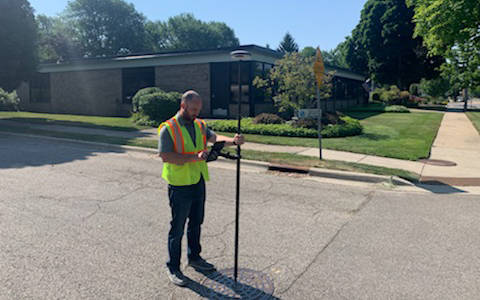
When Heist saw an article about the Leica Zeno GG04 plus GNSS smart antenna with RTK and precise point positioning (PPP) in a trade magazine, he was immediately intrigued. “I saw that it worked directly with ArcGIS Collector—the Zeno Connect app would enable our data collection app to use the GG04 for GPS, so we would be getting amazing accuracy,” he says. “And then there was the fact that I could integrate that directly into our current GIS system with ArcGIS Online. It was a no-brainer.”
He still had to make the business case for the investment, but he had the perfect test scenario. An internal group had recently been formed to address a challenge the company was having around delivering timely as-builts for inspection, and Heist believed the Zeno GG04 plus presented the ideal solution. He rented a unit and put it to use on a road project, where he was immediately able to demonstrate how the smart antenna with its integrated workflow increased efficiency and accelerated the turnaround of deliverables to clients.
“I was able to show the entire workflow—how we collect a point in the field with a specified level of accuracy, and as soon as that point is collected, it’s in our system,” Heist explains. “Everyone on the project can immediately see those points being collected through ArcGIS Online, and the data can also be brought directly into AutoCAD in real time through the ArcGIS for AutoCAD plugin for use in the design work.”
Heist says everyone was impressed with the results, but especially the inspector doing the as-builts. “Instead of having to work with a tape measure and paper design drawings, he got this nice, clean dataset in AutoCAD with all the elevations, asset names and asset types that he could use to create the as-built. He was ecstatic.”
Adding Value to Asset Management
The initial proof-of-concept made it easy to justify the investment. Although the inspection department was the first to benefit from the new approach, other departments quickly followed. Engineers started asking to use the Zeno GG04 plus in their work. Heist, a licensed small unmanned aircraft systems (sUAS) remote pilot, created a drone service within the company and began using the Zeno GG04 for control points. Within months, Moore + Bruggink had purchased a second Zeno GG04, and they’ve recently invested in a third system. Still, demand continues to outpace availability.
“I love how simple it is to get into the field and start using the GG04. I open it up, charge the batteries, connect the unit to the Bluetooth on my iPad, and then I’m off to the races. Add in the level of accuracy it provides and the integration in our GIS workflow—all that together is just hard to beat with anything else.”
– Brett Heist“The engineers use it to go out and take spot elevation shots or to identify specific areas on a road or parking lot—spots where the curb needs to get replaced, or cracks need to be documented,” Heist says. “The inspectors want to use it for everything. Our goal is for every inspector to eventually be assigned one of these units and have it with them at all times in the field, not only to do as-built collection but other things as well. It’s such an easy tool to use to collect accurate information and deliver that into multiple applications and back into the office in real time. The digital workflow is really powerful.”
So powerful, in fact, that it has even caught the attention of the firm’s survey department, where accuracy has always been a sticking point for GIS in the past. “We’re able to get within a tenth to a hundredth for the most part—centimeter-level accuracy—which is pretty remarkable,” Heist says. “This allows us to augment and complement the high-accuracy work being done by our survey team so that we’re all bringing more value to our clients through faster project turnarounds and easy access to reliable information.”
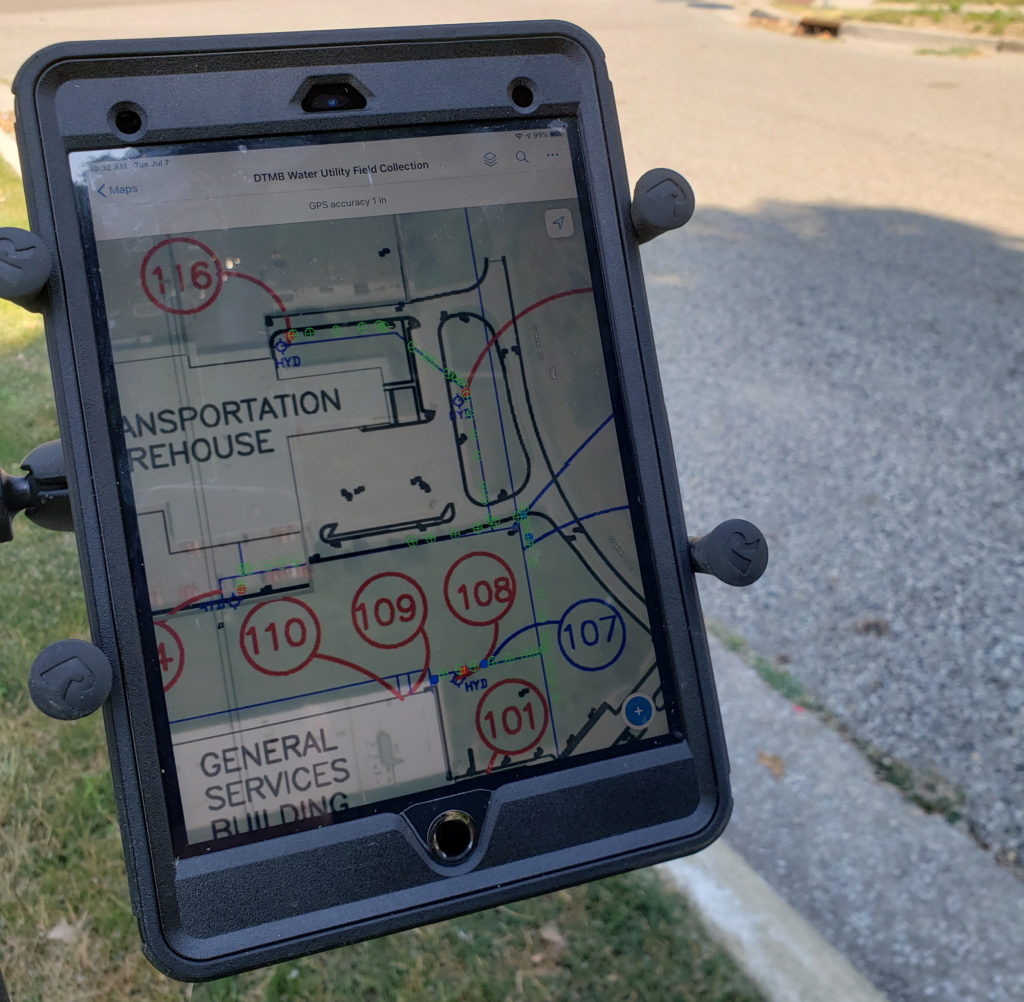
Heist relates how his team was tasked with collecting all the storm water assets, manholes and catch basins throughout the City of Zeeland. They used the Zeno GG04 plus to collect high-accuracy points for all these assets. “The GG04, paired with the ArcGIS Collector app, made field collection a breeze,” he says. “I was able to have a georeferenced atlas of the storm water system overlaid on top of aerial imagery, along with the existing sanitary sewer system that we had previously collected. We have as-built drawings attached to all the sanitary assets for reference. All this combined to give me access to multiple points of data to assist in the collection of the storm assets.”
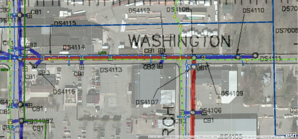
The real-time capabilities of the smart antenna have also helped the team win new projects. For example, Heist was able to show the Michigan Department of Transportation, Management and Budget (DTMB) how GIS could locate all water, main and other assets on one of its campuses, georeferencing the as-built on top of aerial imagery, with that information immediately available in the field and to key stakeholders with the Zeno GG04 workflow. The time savings and accuracy of the process, combined with the accessibility of the data, were significant advantages. “The client can literally open the map and see where we’re collecting and what we’ve collected,” Heist explains. “The whole web GIS capability has just been a game changer in terms of giving people access to data in so many different ways.”
Enabling a Common Visual Language
With the availability of accurate, real-time GIS information, Heist sees the role of the GIS analyst taking on new dimensions. Data scientist, data technician, technical advisor, computer programmer, drone program manager—the opportunities are endless. Factor in the ability to bring 3D models into the GIS to show details from a different perspective, and a whole new realm of possibilities is within reach. “I’ve heard it said that the power of GIS lies in the ability to bring in multiple sources of information and display them in a common visual language, and I’ve experienced that to be true,” Heist says. “Technology plays a huge role in making that happen.”
“We’re saving so much time in the data collection by using this technology, and we’re giving clients a high-quality deliverable that they can turn around and use to add value within their organization as well. No matter what we’re collecting, we can deliver to a high level of accuracy repeatably. That gives people a lot of confidence.”
– Brett HeistFor cities, municipalities, townships and other entities needing accurate spatial data, the advanced capabilities of GIS-savvy engineering firms like Moore + Bruggink are invaluable. In the short term, cost-effective data collection that can be captured by a single operator and accessed remotely from anywhere provides a significant benefit in keeping asset databases current during the challenges presented by coronavirus pandemic. Looking toward the future, sustainable mobility initiatives such as MobileGR in Grand Rapids, where Heist’s team manages a major project, require accurate real-time asset information. And easy access to current, reliable data is the foundation for smart cities.
“Our GIS capabilities enable us to quickly and cost-effectively deliver accurate asset intelligence to our clients,” Heist says. “This is where everything is headed.”
Contact us to explore GIS and surveying solutions that can help you maximize efficiency, productivity and quality.


