

RQAW is a full-service engineering and architectural firm that specializes in transportation, water, site/civil, and public and private sector design project for state and local agencies across Indiana. Though the firm has experienced rapid growth over the last two years, including adding a new MEP department and doubling its 60 employees, there was still room to grow and increase efficiency.
During project development, it is typically more economical to outsource land surveying; however, RQAW found themselves “spending a lot of time and money to outsource [land] survey work and having someone else manage the data,” explains Ryan Perry, PS, the director of RQAW’s new Land Survey department. Bringing those services in-house was a clear opportunity for the company to increase efficiency, quality and consistency.
 “Even when you’re working with reputable vendors, one vendor’s deliverable might be a little different from the next. Now we’re able to provide a consistent data package across the board.”
– Perry
Advantages – And a Challenge
RQAW saw three distinct advantages to adding the new department. First, it would allow the company to achieve consistency in its deliverables. “Even when you’re working with reputable vendors, one vendor’s deliverable might be a little different from the next,” says Perry. “Now we’re able to provide a consistent data package across the board.”
“That, in turn, makes it easier for the engineers to manage their projects,” he adds. “They no longer have to go back and make changes to the data or CAD file and manipulate it to get what they need. It streamlines their efforts and makes them more profitable.”
Bringing survey work in-house also allows the company to improve communication. “Survey’s the first part of any design and there’s always a huge rush to get data initially,” says Perry. “Even if our department is backed up, we can communicate that and manage it a little better in terms of how we time the delivery of everything.”
But there was one significant challenge. The entire survey division, at launch, would comprise three people—Perry as director, a crew chief, and a surveyor in training (SIT). The crew would need to hit the ground running, and fast. Perry knew exactly how to make it happen.
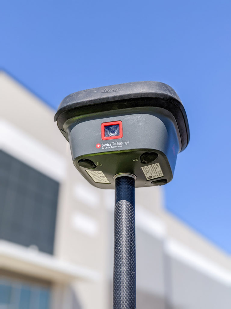
The Leica GS18 I GNSS RTK rover uses visual positioning to capture measurable imagery in addition to GNSS measurements.
The Key to Big Productivity with a Small Team
When choosing the best possible equipment for the new department, Perry recognized that “the biggest factors are productivity and accuracy.” He already knew which brand he wanted for the team’s survey technology. “The quality of the data we get with Leica Geosystems is superior, and the support is fantastic,” he says. Prior to joining RQAW, “I had already been using the GS18 T [GNSS RTK tilt rover]. The time saving component of not having to stand there and plumb the rod every time is significant. But when I saw the GS18 I, I was amazed by the potential.”
The next-generation GNSS RTK rover, the GS18 I has the same tilt capabilities but also has an imaging sensor that allows you to capture photogrammetric measurements from a distance as you walk around a site. You can see the data captured in the field and pull discrete measurement points while onsite using Captivate field software. In the office, any additional measurements needed can be pulled from the images using Infinity Office software, preventing return trips to the field while greatly increasing safety and efficiency.

For Perry, the GS18 I was the key to enabling his small crew to do the work of a much larger team. “The ability to visually compare all the utilities that are coming into a building at a certain point and reference the different utility meters is incredible and you get that documentation as well because of the images,” he says. “Steps and ADA-compliant ramps are also tricky to capture conventionally; with the imaging [in the GS18 I], we’re able to quickly capture a lot of data in those areas and not have to worry about missing something in the field.”
“It’s about how much work we can get done in the amount of time we have with the people we have. Anything we can do to save time will make us more profitable as a department.”
– Perry
The ability to capture images with survey data doesn’t only benefit the survey division. Throughout the company, other departments are seeing the advantages of this innovation. “There’s a lot of detail that isn’t typically conveyed with a survey,” says Perry. “We might show where handrails are entering a building, but we wouldn’t necessarily show what they look like; traditionally, someone else would have to do a site visit to capture the architectural features. But now we have the capability with our survey equipment. We can capture the entrance to a building, and other divisions can go into the data and see the intricate details of that.”

Leading with Innovation
For a company that prides itself on its “relentless pursuit of innovation,” launching a survey department with innovative technology was a smart, strategic move. “It’s about how much work can we get done in the amount of time we have with the people we have,” Perry says. “Anything we can do to save time will make us more profitable as a department. We handle transportation and architectural work all over the state, so if we can be more efficient in the field and cut out the need for a trip back because we missed something, that’s a huge advantage.”
“We invest in technology that maximizes our productivity and enables us to capture more data,” he says, “that allows us to stay innovative and do our best work.”
Related: Interactive PDF Answers FAQs About the GS18 I GNSS RTK


To talk to one of our experts and learn more about how to optimize your surveying potential with technology, please contact us .


