


If you’ve been thinking about adding 3D laser scanning to your surveying capabilities, you’re not alone. In a 2019 survey of geospatial professionals conducted by POB magazine, 27% indicated they planned to add 3D laser scanning to their toolbox, second only to UAVs and data collectors. This followed a 2018 study in which 70% of respondents reported growth in demand for scanning services. The question for most surveying firms isn’t if they’ll get involved in 3D laser scanning, but when and how.
From multistations and scanning total stations to portable and easy-to-use laser scanners, the technology landscape is both intriguing and confusing. While new technologies promise “fast” scanning speeds and “easy” workflows, the information isn’t always quantifiable or comparable. A search on professional forums and social media turns up mixed reviews, leaving you to wonder about the real difference between 2 million points per second and 30,000. Is scanning speed that important, or is there more to consider?
Determine Your Scanning Goals
Brian Elbe, a reality capture consultant for Leica Geosystems with more than 20 years of experience in the surveying profession, says it really comes down to your overall goals. “Do you want it to be a standalone service and start scanning buildings and plants and other applications, or do you want to stay with more traditional surveying workflows? Are you primarily working indoors or outdoors? What types of projects are you going after? All of these considerations will help you identify the technology that is right for you,” he says.
“ With all the recent technology advances, the path is really easy now for any surveyor to get involved in laser scanning. But scanning is different. To be successful, you have to think a little differently and want to go in a new direction, and that’s where new opportunities will start to emerge.”
– Bob KilburnTo provide a real-world comparison between two different scenarios, Elbe recently conducted a side-by-side analysis of the new MS60 MultiStation and the RTC360 laser scanner along with Bob Kilburn, a Leica Geosystems product manager who also has considerable surveying experience. The two men spent 75 minutes scanning a large intersection with an overpass. In that time, the RTC360 captured both sides of the roadway and the overpass with comprehensive data and high-dynamic-range (HDR) imagery, while the MS60 scanned one side without imagery. However, the MS60 data was already on control, while the RTC360 data had to be put into a coordinate reference frame. Point cloud data from both instruments was easily pulled into Leica CloudWorx software for use in a CAD system. Each solution offered significant advantages—depending on the project objectives.
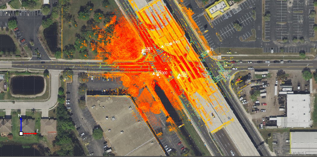
Scan data captured with the new MS60 MultiStation overlaid on imagery.
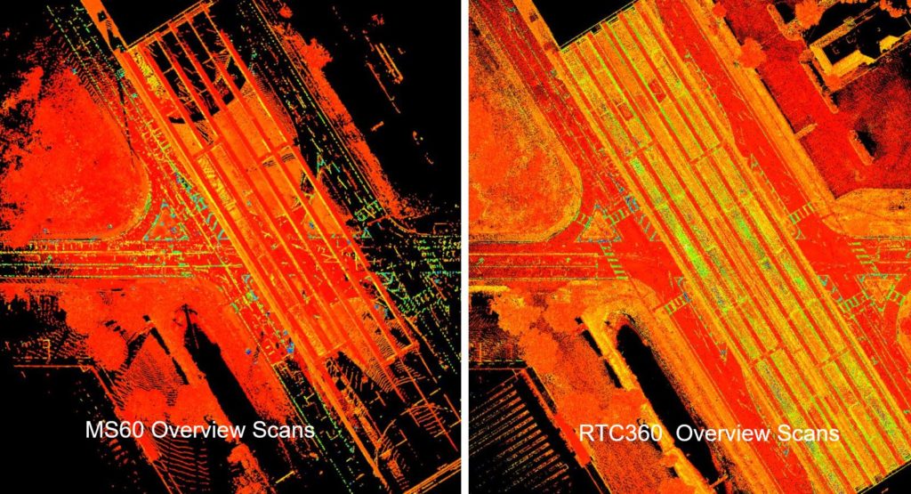
In a scan data comparison between the MS60 and RTC360, the only real difference was the density, and that was based on the objectives of the project that were determined at the outset.
“With all the recent technology advances, the path is really easy now for any surveyor to get involved in laser scanning,” Kilburn says. “But scanning is different. To be successful, you have to think a little differently and want to go in a new direction, and that’s where new opportunities will start to emerge. You’ll want to start thinking now about what that progression looks like because this isn’t just about buying a new instrument; it’s about finding a more effective and efficient way of doing business.”
Learn from the Experts
In an on-demand webinar, Kilburn and Elbe share the results of their intersection test scan and walk you through several other basic applications and best practices. You’ll learn:
- What to look for in a total station with laser scanning capabilities
- When to use a scanning total station vs. a dedicated laser scanner
- What to expect from field and office software
- How to use point clouds to grow your business
“There are a lot of different ways to add 3D laser scanning to your business,” says Elbe. “But the decision involves so much more than just buying a new piece of technology; you really need to be strategic and think about the potential applications and workflows, and also understand the key considerations. Being well informed will help you make the best decision so you can take your firm in the direction you want to go.”
To talk to one of our experts and learn more about how to grow your surveying business, please contact us.


