If you’re assessing your mobile mapping capabilities in terms of megapixels and image quality instead of image value, you’re leaving money on the table, says Jason Ellis. Here’s how to change it.
How much does a single pixel weigh?
In physical terms, a 64-bit pixel is roughly 0.012200703125 kilobytes, and 50 kilobytes weighs about 8,000,000,000 electrons which is somewhere around two ten-thousandths of a quadrillion of an ounce, thus 0.012200703125*8,000,000,000\50 = oh, never mind, the point is: pixels are pretty insignificant… that is, in terms of physical weight.
But how much does a single pixel weigh down your business?
Likely, a single pixel has no bearing on your business. But we don’t work in terms of single pixels; we work in terms of MEGApixels. Thousands of color pixels all lined up to present an image. In mobile mapping, we are collecting a lot of images with a lot of pixels. During collections, the data footprint grows quickly.
For context, I recently collected a 5 mile project, one pass east, one west. It took about 30 minutes and the image data footprint was 80GB. That’s a lot of pixels.
“How much value does each pixel you produce in the field actually bring to your organization? You are paying for all of them.”
So, knowing that mobile mapping produces a lot of pixels, shouldn’t we scrutinize the quality of those pixels? Of course we should. But let’s scrutinize their quality not in terms of image quality, but image value. How much value does each pixel you produce in the field actually bring to your organization? It’s a rhetorical question. I ask because regardless of the value they bring, you are paying for all of them.
You are paying for them in terms of flat cost per pixel. Image sensor cost per pixel. Processing time per pixel. Storage cost per pixel. Transfer cost per pixel.
Maybe it would be easier to consider in terms of overhead. How large are your raw datasets in the field? How long does it take to process them? When you store them on a server or share them with a collaborator, how long does the transfer take? How much does storage cost? Backups? What is the impact on your workstation specs for your production fleet (definitely some cost there).
The High Cost of Useless Information
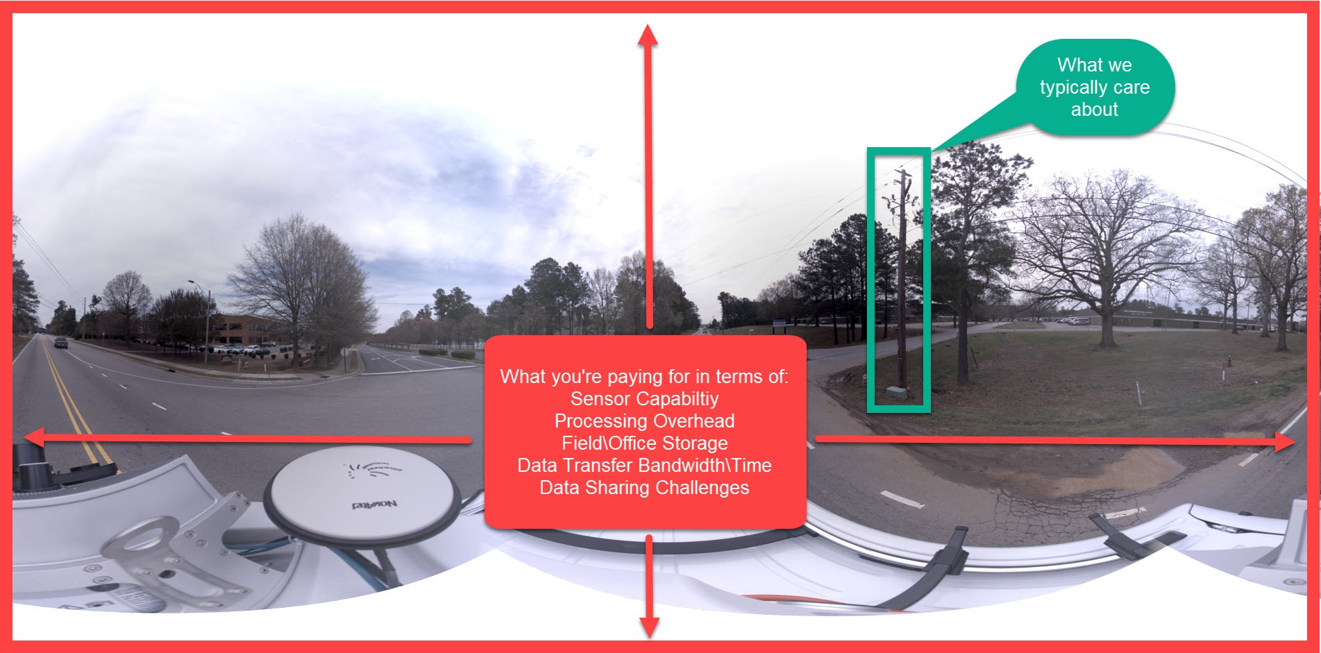
In mobile mapping, we are usually working with data that is in the realm of “wow that’s a lot of data” – gigabytes or even terabytes of data collected in a short amount of time. But if we are working with that much data, should it not be rich in value? I am talking about focused data. Not focus as in the sharpness in imagery, but focus as in showing us what we want to see and omitting as much useless information as possible.
If someone told you that their mobile mapping system had a 100 megapixel panoramic camera on it, would you be impressed? Probably – that’s a lot of pixels! But if they told you that 90% of the pixels in any panoramic image they gave you were useless in terms of value, then how would you feel? If you were paying for 100% of that data, 100% of the processing overhead, 100% of the storage, 100% of the transfer times, you would probably be unimpressed to learn that only 10% of the data actually brings value to your operations.
In many cases, the vast majority of pixels in a panoramic image are for reference and only small concentrated areas of the image have any value to us. Why do we need high resolution images of vapor clouds, the sun, trees, the top of our collection vehicle (over and over again) lawns, etc., when all we really wanted to see are connection points at the top of a pole? Now, this is just an example, but perhaps you get the point – we’re likely overpaying for mobile imagery in many different ways!
A Smarter Approach to Imagery
Enter the Pegasus TRK. This system introduces the concept of SmartFusion Imagery. What this means is it delivers the highest resolution information, but in the areas you actually care about, saving time and money in your capture and analysis.
The new binocular “butterfly” cameras can be configured in horizontal or vertical configurations, giving a more deliberate and focused configuration as opposed to capturing absolutely everything within sight every time the cameras trigger.
In the horizontal configuration of these cameras (pictured below), it is able to cover things immediately adjacent to the roadway in terms of signage, storefronts, guardrail and utility features.

“This is a whole new approach to imagery in mobile mapping. One that is … better for the cost of ownership, better for collection and processing overhead, better for analysis, and better for your business.”
In the vertical configuration, it covers bridge components, overhead utilities, tunnel details, building facades, etc. It is also possible to run a set horizontal and the other set vertical. The Pegasus TRK is facilitating smart collection of assets in a very deliberate manner, allowing for a more cost-effective approach to mobile mapping.
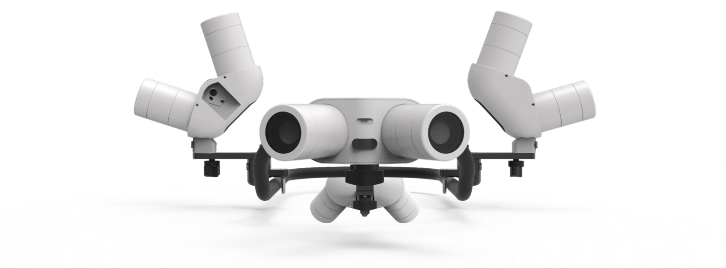
The “halo” or “sweep” of high resolution images it produces provide a focused capture equivalent to what is captured on a 156MP panoramic camera, all due to concentrating on what is important, and omitting everything else.
Here is an example in the new Leica Cyclone Pegasus Office software and how it uses a 24MP panoramic camera for reference and colorization of the LiDAR, but then focuses in on important features in high resolution with the binocular “butterfly” cameras.
This is a whole new approach to imagery in mobile mapping. One that is well thought out and brilliantly implemented, and not just for the sake of being different, but for the sake of being better. Better for the cost of ownership, better for collection and processing overhead, better for analysis… better for your business!
About the Author:

For over 20 years Jason Ellis has been an agent of change by way of technology and a passionate advocate of all things geospatial. Every day he works to help organizations transform their potential by exploring and implementing mobile reality capture solutions. As the North American mobile mapping sales and technical consultant for Leica Geosystems, he works closely with collaborators who are driving reality capture and helping to shape the landscape of the industry. Follow Jason on LinkedIn.
To talk to one of our experts and learn more about mobile mapping or other ways to optimize your surveying potential, please contact us.


