LEARN MORE
WATCH NOW - Monitoring 101: Easy Ways to Launch and Grow Your Monitoring Capabilities >
Learn how to take your campaign monitoring services to the next level in Part 1 of our Monitoring webinar series.
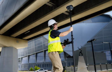
Structural monitoring is a high-demand service that is ideal for surveyors. Learn how to grow your business in campaign monitoring with a simple and inexpensive field app.

Available On Demand
WATCH NOW >
WATCH NOW - Monitoring 102: Using Total Stations and Laser Scanning to Provide Real-Time Results >
Expand your monitoring capabilities by exploring the next level of automation.
Total stations are the most common instrument used for installed monitoring systems, but recent technology advances also make it possible to use laser scanning. Learn the basics in this session.

Available On Demand
WATCH NOW >
Why Monitoring is a Surveyor's Service >
Asset monitoring is already becoming standard in urban construction and will become routine as cities continue to get more dense and build upwards. Are you capturing your share of this growing market?
“Surveyors are already experts in optical and GNSS measurements, and these are the two most commonly used sensors in asset monitoring. Surveyors are also good at analyzing measurement data and preparing reports … and that’s asset monitoring, in a nutshell.”

When to Use GNSS Monitoring >
If asset monitoring is part of your firm’s business plan, don’t automatically assume that total station monitoring is the way to go. In many cases, monitoring networks that include, or are wholly composed of, GNSS receivers are the most appropriate and most cost-effective solution.

“Where just a few points need to be monitored, as on a dam, GNSS receivers can be the better choice because they work in all weather (total station monitoring can be shut down by fog, rain, or snow), they don’t require long lines of sight to ground-based control, and they update 3D position continually without needing to reference other earthbound points.” READ MORE >
On Demand Webinar: How to Optimize Structural Monitoring >
Learn how to leverage the latest monitoring technology innovations to provide intelligence, protect assets and save lives.
“We know unequivocally that structures move. But when do they move? Where do they move, and by how much? In which direction—horizontally or vertically? What factors influence the movement? And what is the impact of that movement—is it causing additional pressure on some other structure, deforming alignment or presenting an increased risk? Knowing this information is crucial to protecting life and assets. Technology enables us as surveyors to answer all these questions.”

William T. Derry, Prof. LS
WATCH NOW >
The Power of Real-Time Monitoring

With real-time monitoring, movement and displacement can be detected within seconds and immediately conveyed to key stakeholders and the public. In this video, Joel Swenson, senior geotechnical engineer at Barr Engineering Co. based in Minneapolis, explains how technology sets the firm apart and empowers professionals to provide outstanding service.


To talk to one of our experts and learn more about how to optimize your surveying potential with technology, please contact us.