

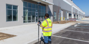
Streamline your surveys and avoid return site visits knowing you can pull any measurement you need from the dataset once you’re back in the office.
Wouldn’t it be great to know all possible engineering and design needs for your survey data before you go to the field? With the GS18 I GNSS RTK rover, you can simply walk around the site in minutes and be confident you can answer every question without a return visit.
>> Explore the interactive demo
LEARN MORE
How RQAW Makes Surveying Smarter
 An in-house surveying department with innovative GNSS technology gives an Indiana-based engineering and architecture firm an edge in safety, productivity and service excellence.
Interactive PDF Answers FAQs about the GS18 I GNSS RTK
 This PDF covers the questions surveyors are asking most about the new GNSS RTK with visual positioning.
On-Demand Webinar Shows How to Use GNSS Innovations to Optimize Your Surveying Field Workflows
 Advanced signal tracking, self-learning capabilities, tilt compensation, visual positioning—the latest advances offer big advantages.
On-Demand Webinar Shows Optimal Survey Data Workflow Using Infinity Software
 If you’re still taking your GNSS and other survey data directly from the field into CAD, you need to see what you’re missing.
How to Truly Benefit from GNSS Modernization
 Taking full advantage of new satellites and multifrequency signals requires dynamic surveying technology.
Technology Review: New GS18 I GNSS RTK Rover Yields ‘Impressive Results’
 How does the GS18 I perform in the real world? Gavin Schrock of Geospatial World evaluates the integrated sensor technology.
To talk to one of our experts and learn more about this groundbreaking new solution, please contact us .


